Combined Transport in the Baltic Sea Region – GIS Framework
Project description
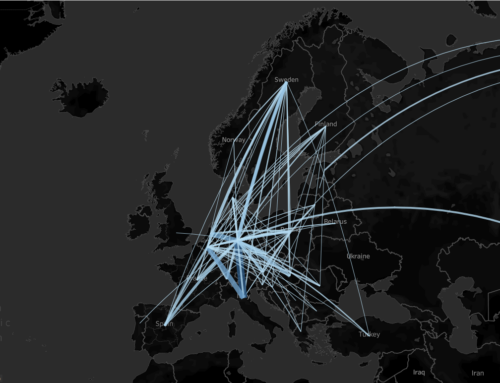
SGKV – Studiengesellschaft für den Kombinierten Verkehr e.V. is a project partner in the Interreg project COMBINE. The results of the project should enable a better understanding of combined transport (CT) in general and in the Baltic Sea region in particular. Within the framework of a data-based work package, the focus is on a goods flow analysis. The analysis should provide specific information on CT flows (volumes), goods (groups of goods) and their structure (mainly used transport modes). It serves as a starting point to describe the design of CT transport chains and to identify potentials and untapped markets.
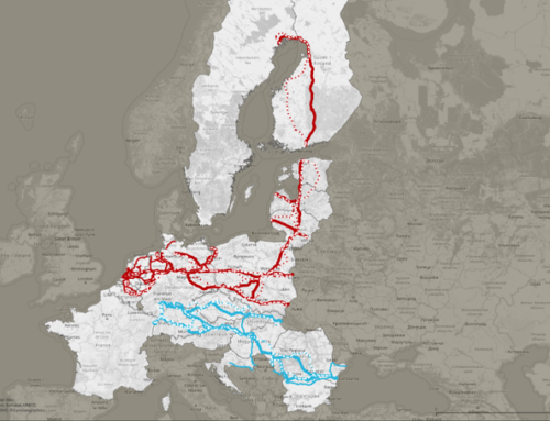
In order to support the above-mentioned tasks, a framework is to be created in a Geographical Information System (GIS). This framework should contain relevant infrastructures and thus enable analyses in the Baltic Sea Region that show the advantages and "missing links" of combined transport. The infrastructures to be implemented in the GIS or their data should primarily come from open source in order to enable a broad use. The framework should take into account the different transport networks, waterways, rail network and road. In connection with the existing terminal database available to the SGKV, environmental analyses can then be carried out in connection with CT infrastructures.
As part of a subcontract, I am creating a GIS-based framework in QGIS for the SGKV for a map-based representation in the sense of the above-mentioned project. For the implementation of the transport networks, I am examining various sources. Open source solutions are in the foreground, as they allow a broad use of the framework. I obtain additional data such as administrative boundaries, structural data on European (sub)areas (NUTS regions, etc.), commercial and industrial areas in the sense of the project and exchange information closely with the AG on which contents are relevant for CT analyses. In addition to creating the framework in QGIS, I provide documentation on the functionality and data description. In addition, I implement the framework at the client's site and introduce its use.
The project language is English.
Further information
Map/picture attribution:
© OpenStreetMap contributors
This product includes data licensed from ©EuroGeographics.
© UNECE, United Nations Economic Commission for Europe 2019
© EuroGeographics for the administrative boundaries
Period
June 2021

Project partners
none
Keywords
Freight transport
Terminal
Data analysis
GIS
Europe
Tableau